

CONCRETE STRUCTURE SCANNING
Concrete Structure Scanning is another form of Ground Penetrating Radar, this type of GPR can be performed in a multitude of ways from an array of GPR equipment on the market. Concrete Structure Scanning can aid clients with general damage prevention or factually gather all of the analytical data regarding reinforcements, voids, concrete thickness, and possible hazards such as live electrical wires or plumbing lines. At Axis Building Detection we don’t just offer generic GPR, we have industry-specific GPR units that can accurately determine reinforcement type, size, spacing, cover, depth, and even augmented reality to take your project planning to the next level.

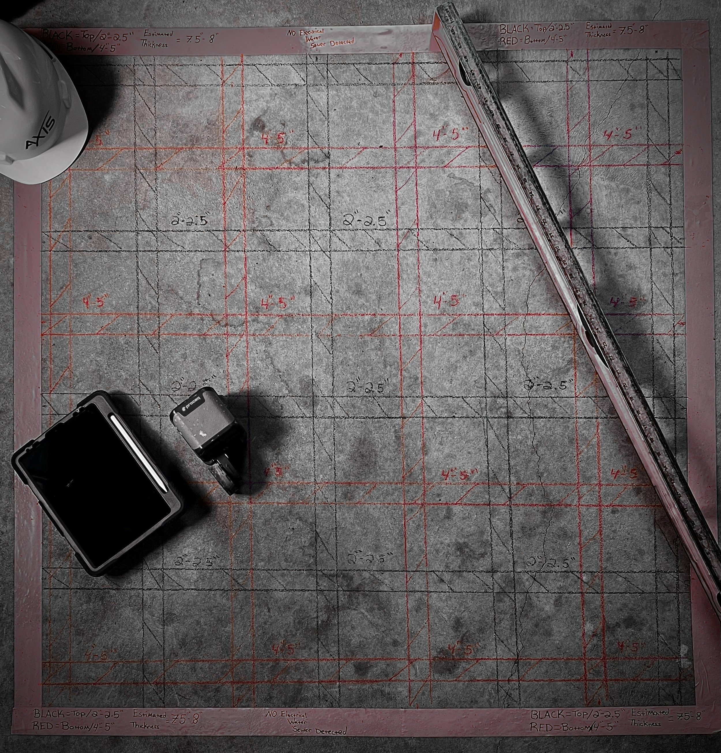
WHY USE GPR FOR CONCRETE STRUCTURE SCANNING?
Concrete structures are vital components of modern infrastructure, but they can also be complex and challenging to construct and maintain. Traditional methods of identifying subsurface elements within concrete structures involve destructive testing, which can be time-consuming, costly, and hazardous to workers. GPR offers a non-destructive, safe, and efficient way to scan concrete structures and identify subsurface elements without damaging the structure or putting workers at risk.

HERE ARE SOME OF THE BENEFITS OF USING GPR FOR CONCRETE STRUCTURE SCANNING:
Non-destructive testing: GPR does not require drilling, cutting, or coring into the concrete structure, making it a non-destructive testing method that preserves the integrity of the structure and minimizes the risk of damage.
Saves time and money: GPR can quickly scan large areas of concrete structures, reducing the time and costs associated with traditional destructive testing methods.
Improves safety: GPR scanning is a safe, non-invasive testing method that eliminates the risks associated with traditional destructive testing methods, such as falling debris, electrical hazards, and exposure to hazardous materials.
Accurate results: GPR provides accurate and reliable results, allowing engineers and contractors to make informed decisions about the construction, maintenance, and repair of concrete structures.
Minimizes disruption: GPR scanning is a quiet, non-invasive testing method that minimizes disruptions to ongoing construction activities, making it an ideal choice for use in occupied buildings or sensitive environments.

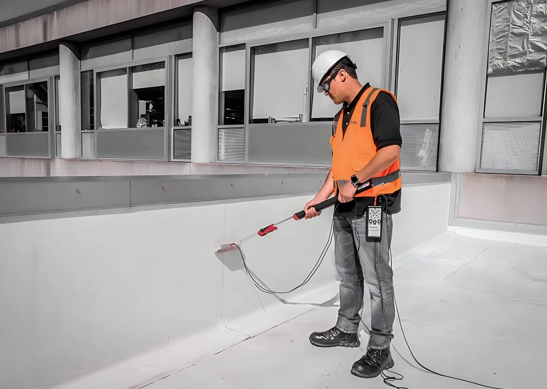
ELECTRONIC LEAK DETECTION
Electronic Leak Detection (ELD) is a method of finding leaks in roofs, walls, and floors using electrical conductivity. The process involves using a low-voltage electrical current to locate breaches in the waterproofing membrane or coating. ELD is commonly used on flat roofs, where water can easily pond and penetrate through any vulnerable points.
How Electronic Leak Detection Works
Depending on the system, a conductive primer may be required, and will first be applied under the membrane.
The area is watered down.
A technician with a handheld electronic scanner attached to a grounding cable scans the membrane in search of breaches.
A breach is identified by detecting a water path to the building ground which completes an electrical circuit.
When the scanner crosses a breach, the electronics on the scanner will make both an audible and visual notification.

ADVANTAGES OF ELECTRONIC LEAK DETECTION
-
Immediate identification of breaches leading to potential water intrusion in roofing, waterproofing, or coating membranes.
-
Breaches can be repaired and retested the same day.
-
Reduction of potential or further water damage due to immediate identification.
-
Rapid inspections compared to traditional flood testing which could cause interior damage and per ASTM standards require 48 hours minimum time period
-
Conductive primer applied is approved for use on various systems from different types of non-conductive roofing, waterproofing, and coating manufacturers. It will not void manufacturers’ warranties.
TRU GROUND APPROVALS
Written approvals:
Carlisle Coatings & Waterproofing
Carlisle Syntec
C.I.M. Industries
Duro-Last
FiberTite
Flex Roofing Systems
Freedom Chemical Corporation
GAF
GCP Applied Technologies
Hydrotech
Project by project approvals:
Firestone
Johns Manville
Sika Corporation
Sika Sarnafil
Tremco Roofing
Hyload
IKO
Kemper
Malarkey
Mule Hide
OMG RhinoBond
Polyguard
Siplast
Soprema
Tremco Coatings
Versico


GROUND PENETRATING RADAR
Ground Penetrating Radar or GPR is the process in which a transmitter sends a pulse into the ground or structure and records the echoes that rebound off subsurface objects such as underground utilities, structural reinforcements, obstructions, voids, and more. GPR is an umbrella term that covers a broad range of specialized equipment, because of this it is important to understand the different types of GPR available on the market in order to maximize the amount of data that is relevant to your project and specific needs. At Axis Building Detection, we provide multiple variants of GPR to assist our clients in making informed and educated decisions based on what may be below. This increases job-site safety, reduces project costs, and greatly reduces the probability of costly damages commonly associated with excavation, coring, boring, cutting, and drilling.

HOW GROUND PENETRATING RADAR WORKS
During GPR, a radar unit will emit and receive thousands of signals per second which are then transmitted to a monitor. The results are then saved and stored for future review. Many GPR methods create visual slices of an image to generate a three-dimensional map with depth, soil type, and object locations as major features.


WHAT CAN GPR DO?
Ground-penetrating radar can map the subsurface to detect underground obstructions such as pipes, utilities, leaks, and line breaks in a way that is non-intrusive. The results of mapping with GPR can make a huge impact on the scope and direction of our construction projects.
GPR provides a complete picture of the job site, both above and below the ground. GPR can avoid potentially perilous situations from hitting a major utility such as a water main or a power line. Less digging is an advantage of use with GPR, saving clients time and money.

PRIVATE UTILITY LOCATING
Private Utility Locating is a rapidly growing industry for good reason, it has proven to be effective in project planning, damage prevention, updated geological surveying, and overall job-site safety. As the industry has evolved the technology has evolved with it, incorporating Ground Penetrating Radar with Electromagnetic Locating has become the industry standard for preventing costly damages to our civil infrastructure. While reducing the probability of encountering an undocumented utility line down to almost zero, it has also helped increase project productivity by pinpointing specific utilities, their depth, start-stop points, and even where a line has been damaged or become blocked. This takes the costly guesswork out of repairing or replacing specific utilities while promoting safe excavation and protecting our valuable infrastructure.
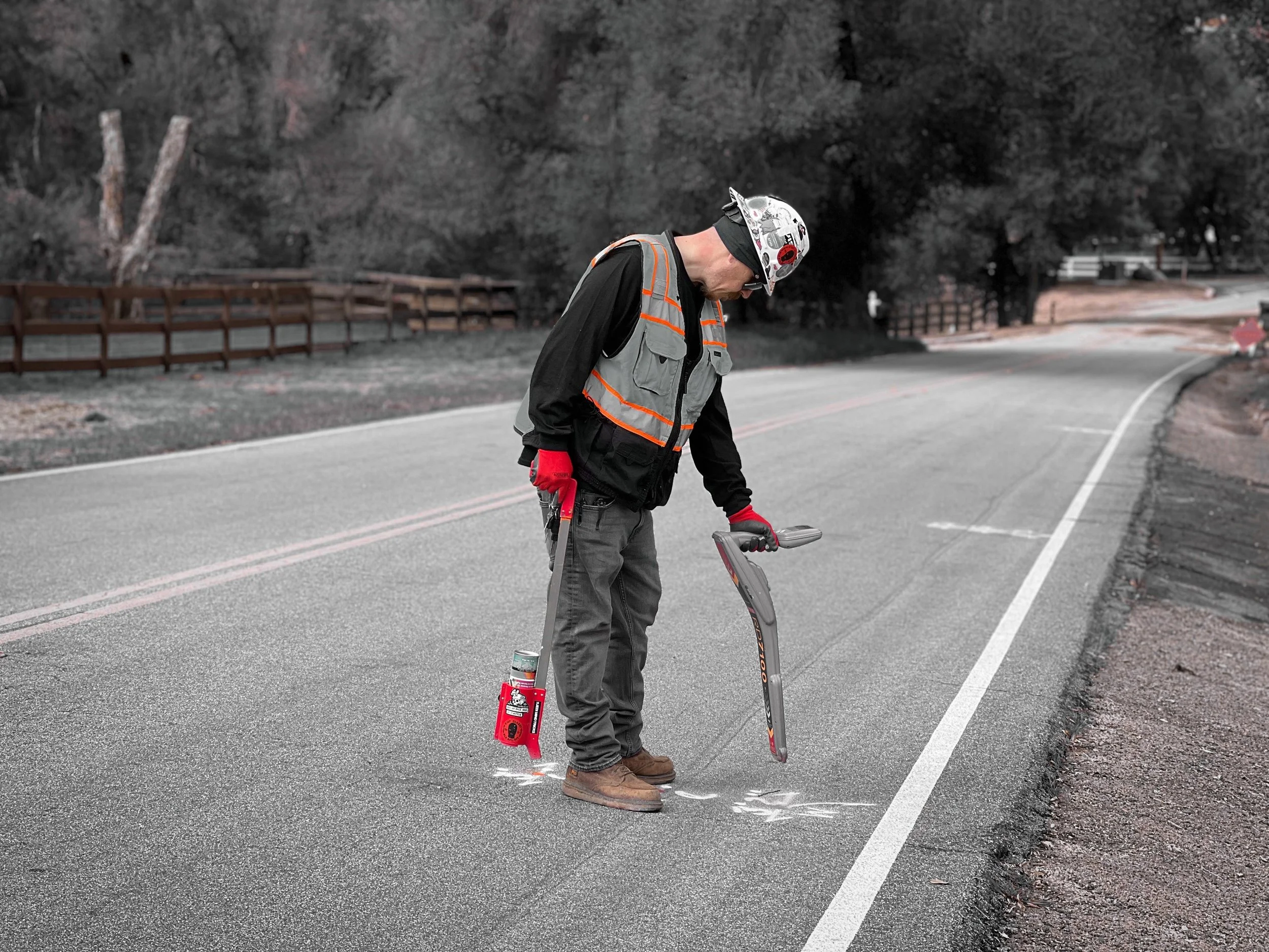
WHAT IS ELECTROMAGNETIC LOCATING?
Electromagnetic locating is a non-destructive testing method that uses electromagnetic signals to locate and map underground utilities and infrastructure. This method involves transmitting an electromagnetic signal from a transmitter device through the ground and detecting the signal with a receiver device. The receiver device then measures the strength and direction of the electromagnetic signal, allowing the location and depth of the underground utilities and infrastructure to be determined.
WHY USE ELECTROMAGNETIC LOCATING FOR PRIVATE UTILITY LOCATING?
Private utility locating is necessary to avoid damaging underground utilities and infrastructure during excavation or drilling activities. Electromagnetic locating is one of the most commonly used methods for private utility locating because it offers several benefits over other methods.
Non-destructive testing: Electromagnetic locating is a non-destructive testing method that does not require excavation or drilling into the ground, preserving the integrity of the property and the underground utilities and infrastructure.
Saves time and money: Electromagnetic locating is a fast and efficient method for locating underground utilities and infrastructure, reducing the time and costs associated with traditional excavation and drilling methods.
Improves safety: Electromagnetic locating is a safe method for locating underground utilities and infrastructure, eliminating the risks associated with traditional excavation and drilling methods, such as damaging underground utilities, causing gas leaks, or creating hazards for workers.
Accurate results: Electromagnetic locating provides accurate and reliable results, allowing engineers, contractors, and property owners to make informed decisions about excavation and drilling activities.
Minimizes disruption: Electromagnetic locating is a quiet and non-invasive testing method that minimizes disruptions to property owners and neighboring properties, making it an ideal choice for use in residential areas or commercial properties.

UNDERGROUND UTILITY MAPPING
Axis Building Detection is proud to offer Underground Utility Mapping, this service can be provided in a few different ways. The first produces a digital map that contains all the analytical data collected while performing Electromagnetic locating & Ground Penetrating Radar, the result is a permanent digital map that can be used over and over, making your locating investment invaluable as the information is still available long after the paint markings have washed away. The second method is known as Augmented Reality, this is a relatively new technology that takes underground utilities or structural reinforcements detected in an area and generates a 3D rendered image, and allows the user to place that image over the area in real-time. This allows the client to put together a very specific plan for their project by not only obtaining all the analytical data of those objects but a visual example of any potential hurdles or problems they may encounter.
HOW IS UNDERGROUND UTILITY MAPPING DONE?
Underground utility mapping is a complex process that involves the use of a variety of technologies and techniques. Some of the most commonly used methods for underground utility mapping include:
Ground Penetrating Radar (GPR): GPR is a non-destructive testing method that uses electromagnetic waves to map the subsurface of the ground. GPR can detect the location and depth of underground utilities and infrastructure and is particularly useful for mapping non-metallic utilities, such as plastic pipes.
Electromagnetic Locating: Electromagnetic locating is a non-destructive testing method that uses electromagnetic signals to locate and map underground utilities and infrastructure. This method involves transmitting an electromagnetic signal from a transmitter device through the ground and detecting the signal with a receiver device.
Vacuum Excavation: Vacuum excavation is a non-destructive digging method that uses high-pressure air or water to break up soil and debris, which is then removed through a vacuum system. Vacuum excavation is used to expose underground utilities and infrastructure without damaging them.
Utility Locating Services: Utility locating services use a combination of technologies and techniques to locate and map underground utilities and infrastructure, including electromagnetic locating, GPR, and vacuum excavation.